Region XI of Chile is an island within the country. In Chile, only accessible by water or air, from Puerto Montt leads the way Southern Highway. Woods, marble caves, fjords and glaciers.

Photography by thejourney1972 (South America «addicted»)
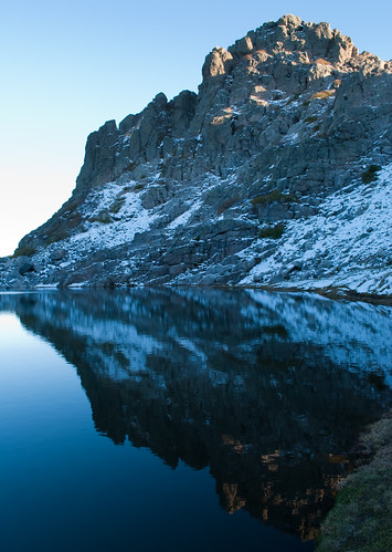
Thunder is heard, a block of ice from the glacier Montt, thousands of icebergs floating on the fjord and channel Baker, the river carries Bertrand cubic 900 thousand meters of clear water per second in Coyhaique rains, and a few millimeters in addition the 1,200 who fall each year, a new coigüe grows in the deciduous forest that covers the slopes of Cerro Castillo, the trout jumping in the calm turquoise lake Carrera. A normal day in the south of Aysen Region XI of Chile.
Fifty years ago, no roads reach these latitudes. The people, heirs to the culture-while tehuelche gauchos drinking mate, played and danced chamamé trick-riding trails circulated drawn from the use or moved through the archipelago, fjords and glaciers, with wooden boats Lenga or cypress. Carry won from Puerto Ibanez, the namesake valley a few kilometers of the border Pallavicini, to the city of Coyhaique, the regional capital located 116 kilometers to the northwest, could take up to two months.
Only in 1976 was definitely pushed the construction of the Carretera Austral Pinochet’s dictatorship ended in narrow and in 1999 concluded the final leg and finally Puerto Montt (Lake District) was connected by land to Villa O’Higgins. Today, runs 1,240 kilometers, 800 in Aysen. However, this route to the edge of the continent is paved only to the town of Villa Cerro Castillo, a village of 800 inhabitants situated at the foot of the mountain that shares its name, 72 miles (pavement) from Coyhaique.

Photography by Don Fulano
The town of Balmaceda (56 km from Coyhaique), official airport of the region receives two daily flights from Santiago (calling at Puerto Montt, where it is filled), and every two or three days from Punta Arenas. Sounds like a lot for an area that has only 100 000 inhabitants and is the most vast in territory. But everything has its reason: from northern Chile, Aysen is accessible only by water or air. Or Argentina, of course. At this point, the range is no longer natural but the international border to the rugged continent sinking into the sea, forming islands and fjords. From the airport, facing east, only 300 meters separate the steppe of Argentina, almost on the border between the provinces of Chubut and Santa Cruz.
From Coyhaique begins the journey through the Carretera Austral south of the region. Just 50 miles away, before the Northern Ice Field begin to cover the peaks of the Cordillera, Estancia Punta del Monte offers rural tourism days that start very early with the sight of large birds, called Condor. The field of family Galillee is a powerhouse of archaeological tehuelches and a space where the activities of a Patagonian farm are available to the tourist: shearing sheep and alpacas, horseback riding, cattle herding dogs and the ubiquitous lamb cooked in Cross to taste with the smoothness of the Chilean cabernet sauvignon.
There are still places in the world where no mobile signal and not receiving mails Blackberrys work. Spaces tend to be far horizon and silence, as those are strung between lakes and valleys from Coyhaique to Villa O’Higgins or Tortel, the two ends of the road.
The gravel road winds through lakes, rivers and mountains until the next major stop, Lake General Carrera, and his first entrance, Puerto Tranquilo. People router, this corner beside the second largest lake in South America after Lake Titicaca (Lago Buenos Aires across the border), provides constant postal ironed blue water, which, in the eyes, rather than in Patagonia felt in the Caribbean, but with a few degrees less. From Quiet are excursions to the glacier explorers, on which walking with crampons and after the stress of walking, resting with a whiskey on the rocks of the Northern Ice Field. But if there’s one thing that stands this meek and enclave tourism growing strongly, is the ride, either by kayak or boat (that is determined by the time), the caves of marble. A few minutes browsing the spring game, the islets that adorn the lake invite you to go inward and learn its secrets. Marble walls and caves of this multicolored rock provide shelter for sailors. The palette of blue, because the lake merges with the sky, peace and the overwhelming silence of these caves are a magic place.

Photography by Hector Garcia
It is difficult to name every river and lake that crosses the road, take the entire article. But those who launch a tour of the southern neighbor has to know that water accompanies the journey as a beacon marking each port of arrival, brings color and bathes the valley steppe mixed (1,000 mm rain per year) where they are rooted beech, coigües and shrubs such as caulk, ñires, Tepas and Nalco.
General Carrera Lake is a narrow, and from there decided to call Bertrand, where glaciers Huemul Huenul and Bridges increase the flow continues to the Pacific. Space ideal for fly fishing, all bathed in this water is kept from 4058 meters up the hill Valentine, the highest in the region. Nearby, the Hudson volcano threat from its crater at 1905 meters over sea level. In this area, three lodges offer packages of up to a week of pure sport fishing and include activities such as canoeing, horseback riding and climbing the nearby hills.

Photography by lautaroj
The highway flirt, and out of the mountains to its final stretch, where he decided to jump right into the hills shaped by the ice and end up facing the sea. Today, with retreating glaciers, the sculpture of the glaciers formed the fjord, as in Norway, are ideal for salmon farming, and only for sailing enthusiasts.
The next stop is Tortel, one of the two ends of this route in Patagonia. Previous stop in the town of Cochrane to buy supplies and send the last text message to family, to enter this town could be the scene of a fairy tale, it is best to lighten the luggage, with no option, leave the car parked in the shade. Located on the fjord Baker and founded in 1955 on the hill Tortel, is a city of streets that are bridges made of cypress Guaitecas (islands north of the region) that require good lungs for up and down the aisles. Timber and fishing town, is the starting point for excursions to the glaciers shipped (tongue of the glacier that overlooks the sea) and Steffens Montt and the Island of the Dead, which holds the mystery of the death of an entire community brought in early twentieth century to work on the operation of cypress.
The tours to the ice are a walk through the fjords. With cap against the south wind and a good jacket, is a journey into the unknown to one of the few areas of this planet that are uninhabited. The crown break the trip: they landed on an island where you look to the glacier Montt, the hosts make the roast while icebergs floating around.

Photography by Miradas.com.br
No section of this route that does not astonish with its colors, no people which might not be friendly or activity that does not end up being cleansing. Argentina is so close to the Chilean song is smooth and round mate, accompanied by hot bread, you can enjoy the rhythm of chamamé or some Rancherita. Chile is the distance, that survives the winter with a lot of firewood and good dishes, inviting especially between September and April, and when the snow covers it. As in southern Argentina, but closer to the sea. Because Patagonia is one, and also has access to the Pacific.
Enjoy your trip to southern lands!
Leave a Reply
You must be logged in to post a comment.
Recent Comments